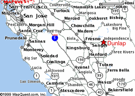
General Info |
Located in the foothills of the Sierra Nevada, Dunlap has attracted foot-launched pilots for more than twenty years. Dunlap is approximately a four-hour drive from the Bay Area, depending upon traffic, how fast you drive and where you live. It is a beautiful place to fly and is one of our most consistent local sites. Dunlap can be soarable all year long, as long as the road to launch is accessible. On good days, it can be soarable from around 10:00 A.M. until sundown. One can expect mellow soaring flights in the morning, very strong conditions mid-day (during the summer) and evening glass-offs. Many PG pilots try to avoid summertime mid-day flights and HG pilots try to avoid landing in the LZ mid-afternoon on hot days.
Pilots must be USHGA members and have a P3/H3 rating or above. P2/H2 pilots may fly at Dunlap, if they are sponsored by an instructor or observer. It is strongly recommended that you get a site intro from an experienced pilot before flying at Dunlap. There are a number of reliable house thermals, as well as some areas you will want to try to avoid. Here are a few things you should know before flying at Dunlap.
Central California Hang Gliding & Paragliding Club (please check here before flying at Dunlap)
Launch and Landing Zone |
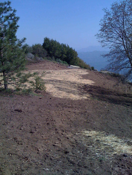
Launch - N36°45'54" W119°05'53" (1423m)
Launch is at 4,600' and faces SW, although the prevailing winds seem to come more from the west. Launch is accessible by 2WD in the summer. 4WD vehicles are required when the road is wet. It takes about thirty-five minutes to drive from the LZ to launch. Half of the drive is on a paved road, the rest is a on a fairly well-graded dirt and gravel road.
There is a port-a-potty at launch and plenty of room for parking and setting up/pre-flighting your wing. In 2008, a grant form the Foundation for Free Flight enabled the landowner to clear and grade the launch area, which is now huge. There is also a ramp launch for HGs. If you're flying with HGs, be sure to yell "CLEAR" loudly before launching. The landowner requests that you do not attempt to land at the launch area.
In respect to the landowners, please follow these rules: 1) No alcoholic beverages may be consumed; 2) No foul language (this is a family environment – save it for the LZ); 3) No smoking; 4) No littering; 5) Stay clear of the house and deck area.
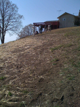
Landing Zone - N36°44'09" W119°06'19" (621m)
The LZ is at 2,000' (not the same as landing at sea level). As with many mountain sites, the LZ can be very turbulent, especially when it’s hot, and it may take some work to land. There are a few obstacles (power lines and trees) to watch out for if you overshoot. Always watch out for traffic when approaching the LZ.
Dan Fleming (flyndan at comcast.net) is the landowner of the LZ. You can camp on his property but Dan asks that you give him a call (559 four three five 3596), ahead of time to let him know that you are coming.
Launch is at 4,600' and faces SW, although the prevailing winds seem to come more from the west. Launch is accessible by 2WD in the summer. 4WD vehicles are required when the road is wet. It takes about thirty-five minutes to drive from the LZ to launch. Half of the drive is on a paved road, the rest is a on a fairly well-graded dirt and gravel road.
There is a port-a-potty at launch and plenty of room for parking and setting up/pre-flighting your wing. In 2008, a grant form the Foundation for Free Flight enabled the landowner to clear and grade the launch area, which is now huge. There is also a ramp launch for HGs. If you're flying with HGs, be sure to yell "CLEAR" loudly before launching. The landowner requests that you do not attempt to land at the launch area.
In respect to the landowners, please follow these rules: 1) No alcoholic beverages may be consumed; 2) No foul language (this is a family environment – save it for the LZ); 3) No smoking; 4) No littering; 5) Stay clear of the house and deck area.
Landing Zone - N36°44'09" W119°06'19" (621m)
The LZ is at 2,000' (not the same as landing at sea level). As with many mountain sites, the LZ can be very turbulent, especially when it’s hot, and it may take some work to land. There are a few obstacles (power lines and trees) to watch out for if you overshoot. Always watch out for traffic when approaching the LZ.
Dan Fleming (flyndan at comcast.net) is the landowner of the LZ. You can camp on his property but Dan asks that you give him a call (559 four three five 3596), ahead of time to let him know that you are coming.
Launching and Landing Fees |
You must join the club and sign a waiver before flying at Dunlap. Funds go to cover insurance and maintenance costs.
Cross Country |
The future of flying at Dunlap depends on the impression we make with the locals. As always, please be respectful of the residents and their property. Dan can hook you up with a driver, Greg Pierson, who can drive you to and from launch (for $5 per person, per trip) or for cross-country retrieves.
The landing strip behind Granny's Knob (in the valley, west of the school) and the ranger station (along highway 180) are also potential LZs, but they can be difficult to reach for PGs. Please exercise caution when attempting to land in these spots.
Where NOT to land: Do not land at the elementary school or on public roads. There is a house between the launch and the school, with a prominent red roof. Do NOT land anywhere near this house or the adjacent properties. The owners have firearms and rottweilers and they will approach you if you land on their property.
Camping and Accomodations |
There is "dry camping" off the road to launch.
You can camp in Dan's LZ, and use the facilities (toilets and showers) in the Dome.
The Sequoia Highlands Camp, near launch, has inexpensive dorm rooms, as well as cabins with kitchens and baths. You can pitch a tent and use their public showers for $15 per night. They also have food service for an additional fee. No open fires are allowed, but you can bring your camp stove, if you're pitching a tent, or use their kitchen facilities. Call 559.336.9425 for directions and reservations. Oh yeah -- they also have a recreation room and a fish pond, in case the wind is uncooperative! They like us there -- be polite, so we can keep it that way!
The St. Nicholas Ranch and Retreat Center offers clean and quiet "lodges" with private bathrooms, dormitories with shared bathrooms (for $15 per night) and RV parking. You must call ahead (559.338.2103) or email([email protected]) for availability and more information.
Squaw Valley Motel
Other Activities - Nearby King's Canyon and the Sequoia National Forest offer alternate recreational activities, such as hiking, biking, swimming and kayaking. There are also a number of motels, restaurants and other campgrounds near the flight park.
Medical Emergencies - There is cell phone access at launch and in the LZ. There is a land-based telephone in the dome. The closest hospital is the Community Regional Medical Center (559.459.6000), located at 2823 Fresno Street in Fresno.
Directions |
Directions to Dan Fleming's LZ and Campground - Take 99S to Fresno. Take 180 E toward Kings Canyon (6.9 miles). Exit at Clovis Avenue. Turn right at 180 E/N Clovis Ave (1.1 miles). Turn left at 180 E/E Kings Canyon Road (13.9 miles). Turn left at 180 (17.6 miles). Turn right at Dunlap Road (3.8 miles). The after passing the elementary school, take the left hand fork onto Millwood Road, just past the Elementary School (on the right).
Directions to Launch - Take 99S to Fresno. From Fresno, exit at Clovis Avenue East. Turn right on Kings Canyon Road (Hwy 180). Take Kings Canyon Road through Centerville and the tiny town of Mettler. About 1 mile after Mettler, turn left at the Hwy 180 sign towards the National Parks. (This left turn is about 15 miles from the intersection of Clovis Avenue and Kings Canyon Road). Drive through Clingon's Junction (your last chance for gas is on the left; Hummingbirds Restaurant is on the right). You will eventually pass "Snowline Lodge" on your left. About a mile after that, turn left on Millwood Road. There will be a sign pointing the way to Sequoia Highlands. Sequoia Highlands is 4.2 miles from Hwy 180. You will drive past the road to Camp Millwood on the right and the road to the Armenian Camp on the left (1.4 miles in). Bear to the right, and it is at this point the gravel road starts. Stay on this road about 3 more miles to Sequoia Highlands (bear left where there is a fork in the road). Follow the signs to Delilah Fire Lookout and for Sequoia Highlands (Delilah is on the same road beyond the camp). Launch is the first road on the left, before you reach the Sequoia Highlands
Directions to Launch - Take 99S to Fresno. From Fresno, exit at Clovis Avenue East. Turn right on Kings Canyon Road (Hwy 180). Take Kings Canyon Road through Centerville and the tiny town of Mettler. About 1 mile after Mettler, turn left at the Hwy 180 sign towards the National Parks. (This left turn is about 15 miles from the intersection of Clovis Avenue and Kings Canyon Road). Drive through Clingon's Junction (your last chance for gas is on the left; Hummingbirds Restaurant is on the right). You will eventually pass "Snowline Lodge" on your left. About a mile after that, turn left on Millwood Road. There will be a sign pointing the way to Sequoia Highlands. Sequoia Highlands is 4.2 miles from Hwy 180. You will drive past the road to Camp Millwood on the right and the road to the Armenian Camp on the left (1.4 miles in). Bear to the right, and it is at this point the gravel road starts. Stay on this road about 3 more miles to Sequoia Highlands (bear left where there is a fork in the road). Follow the signs to Delilah Fire Lookout and for Sequoia Highlands (Delilah is on the same road beyond the camp). Launch is the first road on the left, before you reach the Sequoia Highlands
|
|
Dunlap Weather
Launch Code - Fresno
Soaring Forecast
Sequoia National Forest
Google Map of the Area
An Adventure at Dunlap
Launch Code - Fresno
Soaring Forecast
Sequoia National Forest
Google Map of the Area
An Adventure at Dunlap