
General Info |
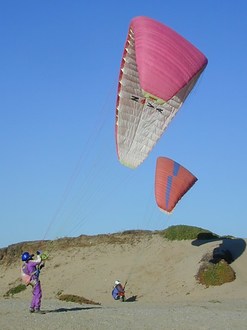
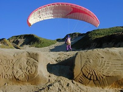
Sand City is seven-mile coastal ridge, off of Highway 1, north of Monterey. The site offers a relatively consistent onshore flow, as the Monterey Bay funnels wind into the Salinas Valley. When the wind is “straight-in,” it is between W and WNW. This is an unregulated site that is flown without permission of the land owners. Please maintain a low profile.
Because the ridge is relatively low, the wind must be fairly strong (~12-15 MPH for paragliders) to generate soarable lift. With a consistent wind and soft sand, Sand City can be a good place for a novice pilot to work on ground handling skills, if you don't mind getting sand in your wing.
Because this is in the same coastal area as Marina and Lake Court it is best to sign in at Marina State Beach if you think you may fly north and land there.
Launches |
Sand City Launch Access:
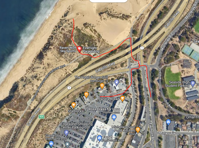
Best access is shown in the map to the left. You can park along Fremont Blvd in certain spots or spread parking in the strip mall parking lot and then follow the path under the highway and then out to the beach.
Best access is shown in the map to the left. You can park along Fremont Blvd in certain spots or spread parking in the strip mall parking lot and then follow the path under the highway and then out to the beach.
Primary Hazards |
Water Landings – There is usually plenty of beach below the entire ridge, but sinking out is common, so stay clear of the water as you land. Water landings can be lethal.
Blow Backs - On high-wind days, stay low and out front (ready to apply your speed bar), to avoid being blown back over the ridge. You should land immediately if you are having trouble penetrating.
Getting Dragged - Always wear a helmet when you’re hooked in and make sure that you can quickly disable your wing in high winds.
Debris – Unfortunately, there is a variety of natural and man-made debris on the beach and launches and the dunes are covered with ice plant. Although this is usually only a nuisance, and it can damage your wing, you should be especially careful that you don’t launch with twigs or other debris in your lines.
Snowy Plover Habitat |
The Snowy Plover is a tiny shorebird, just over six inches long. Plovers nest and forage for food on sandy beaches. You'll see them along the water, finding small crustaceans and marine worms in the wet sand. Unfortunately for the plovers, people and pets can step on their nests, interrupt their foraging and threatening their fledglings.The plover has been on the National Audubon Society's Blue List of declining species, since the list began in 1972, and in 1997, it was listed as an Endangered Species. In an attempt to protect the plovers, California State Parks has erected metal fences, approximately three feet high and 20-30 feet from the base of the dunes, to protect their nesting area during the spring and summer months. These fences, mostly in the northern half of the Sand City/Marina ridge, are very hard to see from the air. Do not walk, launch or land anywhere inside the fenced area. If you accidentally find yourself in the fenced area, get out as soon as possible.
Be especially careful at high tide because the fenced area is so extensive, your landing options are significantly restricted at high tide. Make sure you have safe and legal landing options at all times.
This entire area (except for the launch at Sand City) is a State Park and they take the plover habitat restoration seriously. You will jeopardize our ability to fly this ridge if you don't take it seriously. The site at Montana de Oro, in San Luis Obispo County was closed during this half of the year for plover protection and significant fines are imposed for violations.
Weather |
|
|