
General Info |
Hat Creek Rim is located in the Lassen National Forest. It's a 1,000' ridge that produces consistent ridge and thermal soaring conditions and has excellent glass-off conditions during the summer. With views of Mt. Lassen and Mt. Shasta, it is one of the more beautiful places to fly in California.
"Nearly 1 million years ago, active faulting gradually dropped a block of the Earth's crust (now Hat Creek Valley) 1,000 feet below the top of the Hat Creek Rim, leaving behind this large fault scarp. This fault system is still "alive and cracking."
A heritage of the Hat Creek area's past, it offers magnificent views of Hat Creek Valley, Lassen Peak, Burney Mountain, and, further away, Mt. Shasta. Access is by dirt and gravel roads. This site can be seen parallel and east of Highway 89 in Hat Creek Valley. You'll also notice a fire scarred area on the Rim. This area was burned over during the 1987 Lost Fire which burned over 24,000 acres of land.
The Hat Creek Rim with its gentle late afternoon, early evening thermal uplift, known as "Glass off," provides a unique opportunity for hangliders and paragliders. A launch site and parking area have been constructed on top of this 1000 foot escarpment for this purpose, along with two landing zones directly below the launch. A U.S. Hang Gliding association Intermediate rating is recommended for flying this world famous site." (USDA Forest Service)
Emergency Number
The locals usually use 146.415. The local repeater is 147.030. If there is fire bomber traffic in the area, don't fly. If you're already in the air, land immediately. The closest hospital is Mayers Memorial Hospital. For EMTs, call 530.336.6511.
The Local "911" Emergency Number is 530.252.6632.
Hat Creek Rim Website (check here before flying at Hat Creek)
Season/Flying Conditions |
The most consistent flying generally occurs during the summer months (June through September). During this time, strong south and southwest winds are typical in the afternoon, resulting in strong thermals and turbulence. The flying conditions during the day can range from light soaring conditions in the late morning to strong thermals and ridge soaring (for HGs) by mid-afternoon. If you fly during the mellow morning conditions, you should be aware that the transition from mellow to strong often occurs very quickly. Most PG pilots choose to wait for late afternoon or early evening glass-off conditions. The site usually mellows in the evening (~ 6:00 PM) and the glass-off begins. The glass-off can last until sunset during the summer. Watch out for a sudden loss of lift and stronger wind as the glass-off finishes for the day. And beware -- the mosquitoes can be vicious in the LZ at dusk.
Pilot Proficiency |
PG and HG pilots flying Hat Creek Rim should have an USHGA foot-launched, Intermediate rating and be proficient in Restricted Landing Field (RLF), Turbulence (TUR) and Assisted Windy Cliff Launch (AWCL). Please obey the ridge rules and use caution when flying with faster/slower moving aircraft, as PGs and HGs share this site.
Launches |

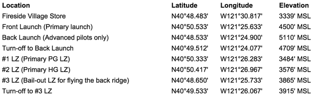
Hat Creek Rim has two launch areas, the front launch and the back launch. Be aware of the density altitude when launching. Please keep all roads clear and remove all litter.
Front Launch - Located on the front ridge, the front launch is the primary launch for PG and HG pilots. It has a large parking and set-up area. There is a toilet, but no shade or water.
Back Launch - The Back Launch is located a mile or so south on the back ridge, adjacent to an old Forest Service lookout. The Back Launch is a cliff launch and is used primarily by HG pilots. The Back Launch should be used by seasoned veterans only.
LZ's |
Hat Creek Rim has three designated landing areas. The #1 and #2 LZs are below, and easily visible from, the front launch. The #3 LZ is in front of the back launch, but it is not visible from launch and it has no permanent windsock. Pilots should visit and inspect the landing areas before flying. Be prepared for a pronounced wind gradient in all landing areas.
#1 LZ - The #1 LZ is directly below, and visible from, the front launch. It is the primary LZ for PGs and a bailout LZ for HGs. The #1 LZ can be technically demanding for HGs and it is not recommended for novice HG pilots.
#2 LZ - The #2 LZ is the largest LZ and is most frequently used by HG pilots. Generally, the wind comes from the west or southwest. This requires the pilot to use the width of the LZ to land. Density altitude and a wind gradient (the wind at tree-top level can be strong, while the wind at ground level is minimal) are key factors to consider when landing. Mid-afternoon landings in the summer can be treacherous. The most friendly time to land is when the shadows have crossed the field and the conditions are mellowing. The north half of the landing area is private property. We've been asked not to land, camp, park or breakdown on this property. A line of very small white rocks, and the permanent windsock, indicate the property boundary.
#3 LZ - There is no permanent windsock in the #3 LZ. There is sparse, small debris and low brush in and around the area and you will land slightly uphill. Check the LZ before you fly. Landing before 6:00 PM during the summer can be demanding. There is a 540' ridge (part of lower Hat Creek Rim) 2,481' directly upwind of the #3 LZ. The road into the #3 LZ is not improved and requires good ground clearance (2WD/4WD). There is little shade and no water is available. It's a 1.2 mile drive from the main (22) road to the #3 LZ. The access road (where it leaves the 22 road), has "LZ" carved on the south side of a small stump.
XC Flights and Fly-Ins |
All cross country flying should be done in an easterly direction (behind the ridge). The entire Hat Creek Valley is private property and it has no designated landing areas. Please respect the wishes of the private landowners by not landing on private property. We are very fortunate to have the support and respect of the local residents and landowners and we can maintain this respect and support by supporting and respecting them and their wishes.
There are usually fly-ins over Memorial Day weekend, the Fourth of July and Labor Day weekend.
There are usually fly-ins over Memorial Day weekend, the Fourth of July and Labor Day weekend.
Directions and Access |
Take Highway 80 East towards Fairfield. Merge onto Highway 505 North. At the Highway 505 Exit, bear left (Northwest) onto Highway 5. Go 128 miles and turn right (East) onto SR-299. Go 55 miles and turn right (South) onto SR-89. Go 11 miles and turn left onto Doty Road. On your left, you will see Fireside Village. You can stop at the Fireside and pick up a site guide at the pilot bulletin board or in the store.
There is 2WD access to the front launches and LZs. Please drive carefully and moderate your speed. The main dirt road leading to launch is well-traveled, as are the roads in and out of the landing areas. Watch for oncoming traffic. The roads in and out of the landing areas have been improved for our convenience. Please don't drive on them when wet conditions can cause damage.
Flying at Hat Creek Rim is permitted through a Special Use Permit issued by the U. S. Department of Agriculture--Forest Service. The site is patrolled by Forest Service Law Enforcement Officers. You should conduct yourself in a manor within the law. Citations have and will be issued to anyone who fails to recognize and comply with the law.
Accommodations/Amenities
Gas is available in Burney and at the Old Station Chevron (530.335.7117), located on Highway 44, ~10 miles south of Fireside Village. They have a small store, ice, propane, etc.
Hat Creek Hereford Ranch Campground and RV Park (530.335.7171) is six miles from launch. It has campsites with shade (and some on grass), hot showers, fishing, swimming, a children's playground, washers and dryers and a small store. There is usually space available, but you should call in advance to reserve a space on holiday weekends.
Camping |
"Dispersed camping" (aka "dry camping") is permitted near launch and in LZ #1.
Generally, no fires are allowed in any of the flying areas at Hat Creek Rim after the end of June and no fires are allowed outside of designated sites, with the exception of portable stoves using gas, jellied petroleum or pressurized liquid fuel. Designated sites include developed campgrounds, picnic areas and signed fire safe sites. Smoking is not permitted, except in an enclosed vehicle, building or at a developed recreation site or other designated fire safe area. Operation of internal combustion engines is only permitted on roads or on designated trails. (A road is a minimum of eight feet wide and can be traveled by a 2WD vehicle, without the exhaust touching vegetation. A designated trail is indicated by a sign or marker.)
If you plan to camp away from a developed campground, please comply with all fire regulations and/or restrictions. Your free "REQUIRED" campfire permit is available at the USFS center on Hwy 89 (just south of Fireside) and at the Old Station Visitor Center and CDF in Johnson Park. Campfires in the LZs (and outside all established campgrounds) are usually banned by the end of June due to fire danger. Check for current fire restrictions.
Other Activities |
Hat Creek is located in the Intermountain Area communities of Burney, Fall River Mills, Hat Creek and Old Station. In the shadow of Lassen Peak, seven campgrounds and four picnic areas are nestled along ten miles of Hat Creek. The are abundant opportunities for fishing, hiking, camping, picnicking, wildlife observation and natural history. Lava tubes, dormant and extinct volcanoes, massive lava flows and fault lines reveal a volcanic past.
Burney Mountain |
Pilots flying Burney Mountain should have a P3/H3 rating (or equivalent skills) and be proficient in RLF, TUR and AWCL. Burney Mountain is located across the valley from Hat Creek Rim. The setup area at Burney is at 7,800' MSL. The only LZ for Burney Mountain is at Burney Springs, located on the southeast side of the mountain. Burney Springs is reachable (if you come from the town of Burney side) by following Tamarack Road around the mountain, four miles beyond the turnoff to the lookout. You will pass it directly if you are approaching from the Hat Creek Rim side. Access is 2WD.
Acknowledgements |
Thanks to the United States Forest Service, the Northern California Foot Launched Pilots Association and the Shasta Sky Sailors for their continued commitment to the area. Improved launch and landing areas, parking lots, roads, etc., are a direct result of the excellent relationship between these groups.